WAEC - Geography (2016)
1
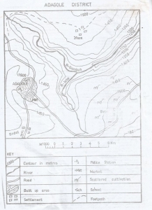
The scale of the map in statement form is
Answer(A)
1 centimetres on the map represents 1 kilometre on the ground
2
Answer(D)
South Eastern part of the map
3
The western part of R. Gembeh flows through
4
The point where R.Isbo meets R.Gembeh is called
5
The contour interval on the map is
6
The lowest point in the map is in the
7
The distance as the crow flies from Bebe to Bodel is
8
The bearing of Bodel from Bebe is
9
Which of the following statements is true about the drainage of the mapped area?
Answer(B)
R.Isbo and R.Gembeh are the rivers that drain the distrint
10
The common modes of transportation in the mapped area are
11
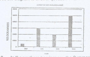
The diagram above represents the export of rice in Kilogrammes from Country X between 2007 and 2010.
What is the name of the diagram above?
12
The diagram above represents the export of rice in Kilogrammes from Country X between 2007 and 2010.
How much rice was produced in 2010 by Country X?
13
The diagram above represents the export of rice in Kilogrammes from Country X between 2007 and 2010.
The total production of rice in Kilogrammes by Country X from 2007 - 2010 was?
14
The diagram above represents the export of rice in Kilogrammes from Country X between 2007 and 2010.
In which year did Country X have the highest production of rice?
15
The planet which revolves around the sun in a clockwise direction is
16
In the southern hemisphere, the summer solstice falls on
17
The planet with the shortest orbit around the sun is
18
What will be the time in Sao Luis, Brazil (Longitude 45o w) when it is noon in London (Longitude 0)?
19
Isothern is a line joining places of equal_______?
20
The ozone layer is found in the
21
Calculate the distance between the equator (latitude 0) and a city Z in Egypt (latitude 30N).
22
Which of the following gases is found in very little qantity in the atmosphere?
23
Which of the following climatic belts has the highest durnal temperature range?
24
Temperature inversion occurs when
Answer(D)
Temperature increases with height
25
Circular depression formed in the bed of an upper course river is known as
26
The most satisfactory explanation for the formation of fold mountain is
27
The cooling and solidification of magma within the earth's crust results in the formation of a
28
The cooling and solidification of magma within the earth's crust results in the formation of a
29
In an oasis, water is derived from
30
The unfolded portion of a fold mountain is called
31
Which of the following features is produced as a result of river capture?
32
Tilting of tree trunks, poles and piling of soil behind a wall are effects of
33
Exfoliation of rock is a result of
34
Answer(C)
Long share drift and wave depositions
35
A water table can be described as
Answer(D)
The general level of underground water in an area
36
Answer(B)
Washing down of soil nutrients
37
When the roof of a natural arch collapses, the resulting rock pillar left standing in the sea is called_____?
38
The high temperature in the interior of the earth may result in the formation of
39
Africa is described as the most tropical continent because
Answer(A)
Most parts of Africa lies within the tropics
40
The introduction of ECOWAS passport among member countries is to promote
Answer(C)
Free movement of people in the sub-region
41
Elements such as wind, water vapour, sunlight and gases which are of benefit to man, animals and plants are called
42
Which of the following is not a timber producing country?
43
What is the name of the trade between one country and another?
44
Which of the following cities is both a harbour and a capital?
45
Which of the following settlements is famous for its ecclesiastical function?