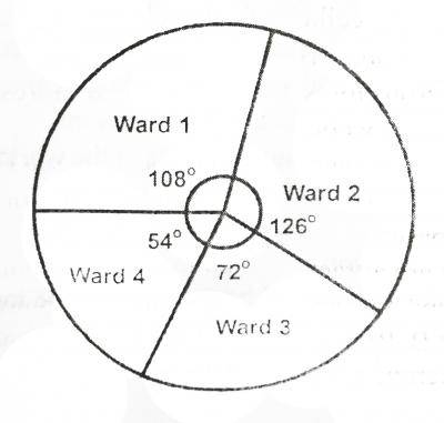
Use the information given in the chart and answer the question. If the total population of the city is 500,000 what is the population of ward 4?
คำตอบ
(A)
75,000
2
Use the information given in the chart and answer the question. An alternative graphic method that can be used to depict the same information is the
คำตอบ
(B)
Chloroplath
3
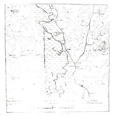
Study the map and answer the question. The Area covered by the map is approximately
คำตอบ
(B)
100km\(^2\)
4
Study the map and answer the question. The bearing of Jata from Adaba is approximately
คำตอบ
(C)
21°
5
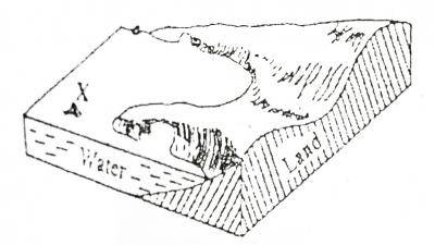
Study the map and answer the question. Intervisibility is possible between the points marked X and Y because the intervening slope is
คำตอบ
(D)
Steep slope
6
Study the map and answer the question. The land-form feature at the centre of the map can best be described as
คำตอบ
(A)
A flood plain
7
Study the map and answer the question. Given that the area show on the map is in Northern Nigeria, which of the following crop combinations would best be cultivated in the area that is liable to flooding
คำตอบ
(D)
Sugar-cane, rice and bananas
8
How were the major mountain belts of the world produced?
คำตอบ
(C)
by folding
9
Along which latitude will be the day time be longest on Christmas day?
คำตอบ
(B)
45°S
10
What commodity is associated with OPEC?
คำตอบ
(D)
Mineral oil
11
Which of the following rocks is composed of the skeletons of microscopic sea plants and animals?
คำตอบ
(A)
Chalk
12
Dodoma is to Tanzania as ______ to Nigeria
คำตอบ
(A)
Abuja
13
Study the table given which shows the mean climatic conditions of station Q and answer the questions.
Month
J
F
M
A
M
J
J
A
S
O
N
D
Temp(°C)
-11
-9
4
3
12
17
19
17
11
4
-2
-8
Precipitation(mm)
28
23
30
38
48
51
71
74
56
36
41
41
The annual temperature range at the station is
คำตอบ
(B)
30°C
14
Study the table given which shows the mean climatic conditions of station Q and answer the questions.
Month
J
F
M
A
M
J
J
A
S
O
N
D
Temp(°C)
-11
-9
4
3
12
17
19
17
11
4
-2
-8
Precipitation(mm)
28
23
30
38
48
51
71
74
56
36
41
41
What type of climate has the station?
คำตอบ
(A)
Cool temperate
15
Which of the following countries has the least potential for the production of steel?
คำตอบ
(B)
Cuba
16
In which of the following countries is cotton growing under irrigation the mainstay of the agricultural economy?
คำตอบ
(B)
Sudan
17
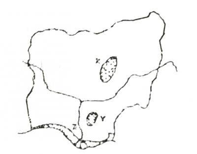
Use the map below to answer the question. The most important minerals found in the area marked X are
คำตอบ
(B)
Tin and columbite
18
Use the map below to answer the question. The major environmental problems associated with the area marked Y is
คำตอบ
(B)
Gully erosion
19
The most extensive vegetation type in the area marked Z is the
คำตอบ
(C)
Fresh water swam
20
A broad-based population pyramid is composed mainly
คำตอบ
(C)
young dependants
21
Fluid basic lava flow is likely to give rise to a volcanic_____________
คำตอบ
(C)
shield
22
In which of the following rock types is petroleum mainly found?
คำตอบ
(E)
Sedimentary
23
One basic mineral that is common to Sokoto, Ewekoro, Calabar and Nkalagu is
คำตอบ
(E)
Limestone
24
Lake Kivu and Malawi are related in that they_________
คำตอบ
(D)
Are rift valley lakes
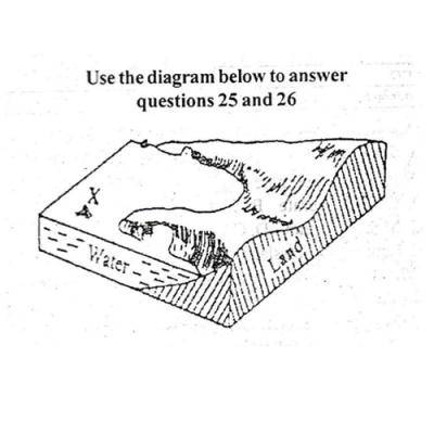
25
Use the diagram below to answer the question. The feature marked X in the diagram is a
คำตอบ
(E)
Cliff
26
Use the diagram below to answer the question. The feature is one of the landforms associated with
คำตอบ
(B)
Wind deposition
27
If the distance between two places on a map is 2cm, while the distance on land is 4km, the scale of the map is
คำตอบ
(B)
1:200,000
28
Soil conservation can be achieved through___________-
คำตอบ
(C)
Strip-cropping
29
The oldest system of agriculture in Nigeria which now survives only in very remote areas is
คำตอบ
(C)
Shifting cultivation
30
Which of these hazard would most like result directly from deforestation?
คำตอบ
(A)
soil erosion
31
The dominant foreign exchange earner of Senegal is
คำตอบ
(B)
groundnut
32
British foreign investments are concentrated in
คำตอบ
(B)
Commonwealth countries
33
The two most important factors which account for the pattern of population distribution in West Africa are
คำตอบ
(C)
Favourable physical conditions and human inertia
34
A desert country which has a high population density supported by irrigation is___________
คำตอบ
(B)
Egypt
35
The greatest volcanic regions of Africa are found in
คำตอบ
(B)
Kenya and Tanzania
36
A type of land-form that is associated with large scale orogeny is a
คำตอบ
(A)
Fold mountain
37
If the time in New York (75°W) is 5.00pm, The time in Nigeria(15°E) will be
คำตอบ
(C)
11.00pm
38
One of the leading industrial nations of the world ranking second in manufacturing output after the USA is__________
คำตอบ
(C)
Japan
39
An instrument used for setting out right angle in surveying a parcel of land is
คำตอบ
(E)
An optical squarer
40
The lack of access to food in some parts of the world emanates from
คำตอบ
(B)
Poor transport system
41
How long does it take the mercury to make a complete revolution?
คำตอบ
(D)
88 days
42
The plains formed when the slopes of mountains are worn back in arid and semi-arid regions my mechanical weathering is called_______
คำตอบ
(C)
Pediplains
43
All the following are examples of intrusive volcanic features except____________
คำตอบ
(D)
lava plateaux
44
Latitude 66 and half marks the____________
คำตอบ
(A)
antarctic circle
45
'It is a port that specializes in receiving and redistributing goods to the neighboring countries'. Which of the following ports is described in the preceding statement?
คำตอบ
(C)
Entreport
46
A well will always contain water if its dug_________
คำตอบ
(B)
To reach sand bearing water
47
When the moon comes in between the earth and the sun________
คำตอบ
(B)
a solar eclipse occurs
48
Lines joining places with same mean annual rainfall are called___________
คำตอบ
(A)
isohyets
49
What type of climate has the station___________
คำตอบ
(A)
Cool Temperature
50
Which of the following is not a form of mass movement?
คำตอบ
(B)
earthquake
51
The innermost section of the Earth is the__________
คำตอบ
(C)
core
52
A line joining places having an equal degree of cloudiness is an___________
คำตอบ
(A)
isoneph
53
Which of the following is not a proof to show that the earth is spherical in shape?
คำตอบ
(D)
twilight and dawn
54
The system of cultivation of tropical commercial crops estates is known as____________
คำตอบ
(B)
plantation agriculture
55
The major environmental problem associated with Area marked Y is____________
คำตอบ
(B)
Gully Erosion
56
A mercury barometer is used for measuring_________
คำตอบ
(B)
atmospheric pressure
57
The feature marked X in the diagram is a________
คำตอบ
(B)
Stack
58
The difference between high tide and low tide is referred to as__________
คำตอบ
(C)
tidal range
59
The feature is one or the land forms associated with_________
คำตอบ
(A)
River erosion
60
If the time at the Greenwich Meridian is 11.00am, what would the local time be at a place 750W?
คำตอบ
(D)
6:00 am
61
Lines joining places of equal sunshine duration on maps are__________
คำตอบ
(A)
Isohel
62
A river transport its load through the following processes except_________
คำตอบ
(B)
plucking
63
A form of chemical weathering is__________
คำตอบ
(C)
carbonation
64
An alternative graphic method that can be used to depict the same information as a pie chart is the___________
คำตอบ
(B)
Chloropleth
65
The Farthest planet from the sun in the solar system is_______
คำตอบ
(A)
pluto
66
The ocean that connects Europe and America is the__________
คำตอบ
(C)
Atlantic ocean
67
Organic components of the soil include all the following except_______
คำตอบ
(C)
Rock pedestal
68
Which of the following winds affects the West Indian Islands of the Caribbean?
คำตอบ
(D)
hurricane
69
The peeling off of surface layers of a rounded boulders during mechanical weathering is called________
คำตอบ
(C)
Exfoliation
70
One of the following does not determine the availability of resources in a country____________