What minerals are found in the Abakaliki area of southern Nigeria?
Отвечать
(C)
Lead and zinc
2
In which of the following vegetation types would you expect to find the baobab, locust bean and acacia as important trees?
Отвечать
(A)
Savannah Woodland
3
In Nigeria, hydro-electric and thermal energy are generated respectively in?
Отвечать
(E)
Kainji and Oji River
4
Which of the following is the major factor responsible for Japan's unparallelled industrial growth in the last few decades?
Отвечать
(D)
Technological proficiency
5
Which of the following BEST accounts for the rural-urban migration in West Africa?
Отвечать
(C)
Lack of job opporunities and social amenities in rural areas
6
The best quality cotton produced in Nigeria comes from the?
Отвечать
(B)
Sokoto-Zaria-Kastina area
7
A resort town is one which?
Отвечать
(B)
exists primarily to help people enjoy their leisure
8
Which of these is NOT true about the tourist industry of Kenya?
Отвечать
(C)
It causes over-population
9
The list below, 1. South Africa 2. Egypt 3. Zimbabwe 4. Kenya 5. Nigeria, in descending order of importance refers to the production of?
Отвечать
(B)
cattle and goats
10
At least 70% of Nigerian total rubber production comes from?
Отвечать
(D)
Bendel State
11
If the distance between two points on a 1:25 000 map is 10cm, what would the same distance be on a map 1:50 000 map?
Отвечать
(E)
5cm
12
One of the objectives of the ECOWAS 'free movement' agreement is to allow a citizen of one country to?
Отвечать
(C)
visit another country for a short period without a valid passport
13
Which of these is a textural classification of soils?
Отвечать
(D)
Sand, loam and clay
14
The load carried by a river is deposited?
Отвечать
(D)
on entering a large body of water
15
Which of the following soil properties can be easily observed in the field?`
Отвечать
(C)
Texture
16
A line joining points equal atmospheric pressure on a map is called an?
Отвечать
(C)
isobar
17
One of the ways in which the deciduous forest differs from the coniferous forest is that?
Отвечать
(D)
the trees are evergreen
18
The greatest threat to wildlife in the African savannah in recent times is?
Отвечать
(D)
bush burning
19
Which of the crops listed below is BEST suited to the following condition? 1. Well-drained soil 2. High humidity 3. Average monthly temperature of 18°C 4.Annual rainfall of between 1500 and 1700mm.
Отвечать
(E)
Oil Palm
20
The difference between towns and villages is that?
Отвечать
(C)
towns perform more tertiary functions
21
The movement of people from a village to a farm settlement may be described as?
Отвечать
(C)
rural - rural migration
22
Which of these are among the ACTIVE FACTORS of soil formation?
Отвечать
(C)
Parent material, time and topography
23
Which of the following is NOT characteristic of the International Date Line?
Отвечать
(D)
Local time is the same on either side
24
Which of these species of trees are suitable for pulp and paper manufacturing?
Отвечать
(A)
Gmelina, fir and pine
25
Which of the following countries has a large number of people of African descent?
Отвечать
(C)
Brazil
26
The climate is characterized by a mean total annual rainfall of between 86cm and 90cm, all occurring within a period of six months: a mean annual temperature of about 280°C with a monthly range of up to 15°C and an annual water deficit in excess of 50cm. The description above refers to tropical ?
Отвечать
(A)
humid climate
27
Heavy engineering involves the?
Отвечать
(A)
location of industries near sources of raw materials
28
Which of the following animals is NOT common in the African savannah?
Отвечать
(E)
Gorilla
29
Rank of the following African rivers (Niger, Zarie, Zambezi and Nile) in order of navigability?
Отвечать
(A)
Nile, Niger, Zambezi, Zarie
30
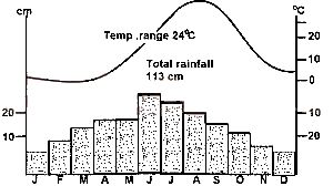
Which of the following statement about the climatic data below is NOT true?
J
F
M
A
M
J
J
A
S
O
N
D
P(in mm)
0
0
2
10
60
118
206
300
155
13
0
0
T(in oC)
21
23
27
30
31
29
26
25
25
27
25
25
Отвечать
(E)
Average monthly rainfall is 70mm
31
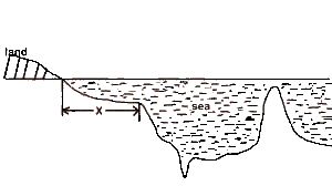
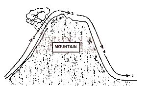
The Feature marked X in the above diagram is
Отвечать
(B)
a continental shelf
32
The feature marked X in the above sketch is formed by
Отвечать
(C)
longshore drift
33
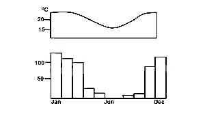
Identify the climatic type illustrated on the above graph
Отвечать
(A)
Warm Temperate Eastern Margin
34
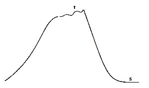
Two points, T and S on the ground as shown in the above diagram, also appear on a topographical map covering the area. Which of the following statements is true about the two points?
Отвечать
(D)
Point S will appear directly south of point T on the topographical map
35
Referring to the above diagram, it is FALSE to deduce that under normal circumstances
Отвечать
(B)
The temperature is lowest at 3
36
The above graphs describe the climate of
Отвечать
(B)
Bulawayo
37
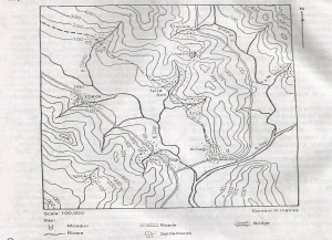
The highest point int he area depicted on the map is just above
Отвечать
(B)
800m
38
The bearing to the nearest degree of the mosque in Amagu settlement from the middle of the bridge across the River Zogo is
Отвечать
(D)
61o
39
The feature through which the River Ngu flows at XX is known as a
Отвечать
(B)
Anticline
40
The major relief feature between the Rivers Zogo and Bidana is a
Отвечать
(E)
Ridge
41
Which of these statements does NOT correctly describe settlements and relief in the area? The settlements
Отвечать
(C)
Not on the immediate banks of the major streams
42
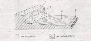
Which parts of the semi-arid landscape shown in the diagram below maybe described as a pediment?
Отвечать
(C)
3
43
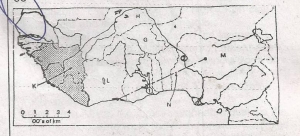
The export trade of the country marked G is based mainly on
Отвечать
(E)
Groundnuts
44
In the country marked H the three leading products in order of importance are
Отвечать
(B)
Livestock, fish and crops
45
The points marked (1) and (2) on the map are both sites of