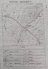
One centimeter on the map represents ½ kilometer on the ground
2
The growth of NONSO settlement is probably because
Răspuns
(D)
NONSO is a nodal town
3
The highest spot on the mapped area is approximately
Răspuns
(B)
1250 metres
4
The distance as the crow flies from Bukola to Balu is approximately
Răspuns
(C)
4.8km
5
The commercial centre in the mapped area is
Răspuns
(A)
NONSO
6
watershed in the mapped area is situated
Răspuns
(C)
on spurs
7
If the map is reduced by half its original size, what would be the scale of the new map?
Răspuns
(C)
1:100,000
8
What is the direction of flow of River Juth?
Răspuns
(B)
Northwest
9
What is the contour interval on the mapped area?
Răspuns
(B)
100 metres
10
Which of the following settlements is nucleated?
Răspuns
(D)
NONSO
11
Figure 1 represents the export of rice by four regions in Country XX in the year 2009. One dot represents 20,000 tonnes of exported rice was used as the scale of the dot map. Study and use the dot map below to answer this question. Which region exported the highest tonnes of rice?
Răspuns
(A)
R
12
Figure 1 represents the export of rice by four regions in Country XX in the year 2009. One dot represents 20,000 tonnes of exported rice was used as the scale of the dot map. Study and use the dot map below to answer this question.
By how much tonnes was the export of rice from region T higher than that from region U?
Răspuns
(D)
80,000
13
The total export of rice for regions R and T is
Răspuns
(A)
180,000 tonnes
14
The sharp pillars hanging from the roof of a cavern in limestone regions are called
Răspuns
(D)
Stalactites
15
Two towns, P and Q, are on the International Date Line and in the same hemisphere. If the distance between the two towns is 444knm and town P Is located on latitude 3°N, on what latitude is town Q located?
Răspuns
(C)
4°N
16
In Koppens's classification of climates, Cs refers to
Răspuns
(D)
Tropical Continental
17
Lines drawn on maps joining places With equal amount of cloud cover are called,
Răspuns
(C)
isonephs
18
Which of the following statements, is accurate?
Răspuns
(A)
There is a distance of 111km for every 1° of latitudinal difference
19
Which of the following coastal features is not due to erosion'?
Răspuns
(C)
Beach
20
In its old stage, a river would
I. be interrupted by waterfalls and rapids
II. flow sluggishly and develop pronounced meanders
III. flow fast and have truncated spurs
IV. develop levees and have a flood plain
Răspuns
(A)
II and IV only
21
The movement of the earth that causes variation in the length of the day and night is
Răspuns
(C)
rotation
22
It is crescentic in shape and it is formed from wind deposition in arid. The statement describes
Răspuns
(B)
barchan dune
23
The type of cloud from which thunderstorms and heavy rain are experienced in the Tropics is
Răspuns
(D)
cumulo-nimbus
24
Which type of mountain is also called the mountain of denudation?
Răspuns
(C)
Residual mountain
25
Which of the following is a process of wind erosion?
Răspuns
(A)
Deflation
26
The weathering process which is commonly found in limestone regions is
Răspuns
(D)
solution
27
Which of the following statements is not accurate about sea and land breeze?
Răspuns
(C)
Land warms up more slowly than the sea during the day
28
The term pyroclastic best describes
Răspuns
(D)
fragmented materials ejected by volcanoes
29
It is composed of layers of ash and cinders alternating with lava. lt has a broad base and steep convex slopes. The above features are associated with a
Răspuns
(D)
composite cone
30
Which of the following pairs are characteristics of igneous rocks? They
I. are stratified
II are metamorphosed rocks
III. are crystalline
IV. originate from molten magma
Răspuns
(D)
IIl and IV only
31
A small difference between the readings of the wet and dry bulb thermometers is an indication of
Răspuns
(A)
low relative humidity
32
Which of the following climatic features describes the Equatorial climate?
Răspuns
(A)
Double maxima rainfall regime
33
The formation of block mountains are best associated with
Răspuns
(C)
uplifting of crustal block within two parallel faults
34
Which of the following landforms is not associated with an advancing shoreline?
Răspuns
(B)
stack
35
The term relative location of settlement refers to
Răspuns
(D)
the position of settlements in relation to others
36
A major cause of rapid population growth rate in Tropical Africa is
Răspuns
(D)
lack of family planning.
37
The most significant factor that led to the revolution in the Japanese industrial sector is the
Răspuns
(D)
inputs of committed and skillful industrial workforce
38
Which of the following reasons account for the low traffic on rivers in Africa?
Răspuns
(A)
Presence of rapids and waterfalls
39
The trade liberalization policy of ECOWAS is aimed at
Răspuns
(C)
promoting economic integration
40
Which of the following is a factor of population growth?
Răspuns
(C)
Birth rate
41
The least important factor in the location of settlements is the availability of
Răspuns
(A)
surface water
42
If the total population of a country is 75,000,000 and its total land area is 250,000km², what is its population density?
Răspuns
(B)
300 persons per km²
43
A major hindrance to foreign investment in Tropical African countries is
Răspuns
(C)
political instability in the countries
44
One of the major problems of manufacturing industries in Tropical Africa is
Răspuns
(C)
inadequate raw materials
45
The transport system which is most affected by climatic factors is