JAMB - Geography (2004)
1
Which is the simplest method of rapid distance measurement in surveying?
2
Tin-mining activities in Nigeria are the main causes of environmental degradation on the?
3
In the Niger Delta, the features that are clearly visible are?
Answer(D)
white sandy beaches, salt-water swaps and mangrove trees
4
Most of the iron ores produced in Africa are exported because?
Answer(C)
they can only be smelted in modern furnaces that are not locally available
5
The oldest system of agriculture in Nigeria which now survives only in very remote areas is?
6
The ECOWAS is comparable to the European Union in terms of?
Answer(C)
the freedom of movement within the community
7
Two examples of inland drainage lakes in Africa are?
Answer(A)
Lake Chad and Lake Edwards
8
The highest lands in Nigeria are found on the?
9
Unemployment and underemployment are at high levels in West Africa cities because?
Answer(D)
industrialization is at a slow pace
10
The port that handles the highest volume of timber export in Nigeria is?
11
Oil production has made much impact on the development of?
12
Textile industries in Nigeria are located mostly at?
13
The major factor responsible for the low population density in the west coast of Southern Africa is?
14
Examples of African rivers with deltaic mouths include the?
Answer(C)
Nile, Niger, Senegal and Volta
15
The proportion of the earth's surface occupied by oceans is approximately?
16
In the humid tropical lands, structure of mature forests is closely related to the demand for?
17
Rocks which contain metals in concentrations high enough to be economically profitable to extract and refine are referred to as?
18
Which of the following groups consists of energy resources?
Answer(D)
Coal, Petroleum and water
19
Spruce, fir and pine are tress found in the?
20
Which of these hazards would most likely result directly from deforestation?
21
The mass of air whose isobars form a circular shape, with low pressure in the centre and increasing towards the outside, is known as?
22
The process by which organic matter is decomposed and synthesized to form part of the soil is known as?
23
In a ecosystem, bacteria and some other microscopic organisms are best described as?
24
The process whereby water changes from liquid to gaseous state is called?
25
A serious environmental hazard which causes both vertical lateral displacement of part of the earth's crust is?
26
If the standard time is of a country is GMT + 1hr, which longitude's local time is adopted by the country?
27
Migrant-receiving areas tend to be characterized by?
Answer(D)
extensive industrial development
28
The settlement pattern associated with pastoral farming is?
29
Air transportation is poorly developed in the Third World because of?
30
Squatter settlements are indicative of?
Answer(D)
the great pressure on available housing
31
A modern method of animal rearing in which pasture is grown for the animals is called?
32
The invisible component of international trade consist of?
Answer(C)
financial service and tourism
33
The human factor that contributes to the population growth of an area is?
34
The areal expansion of towns leads to the?
Answer(B)
takeover of agricultural lands
35
The country that relies heavily on imported raw materials for her industrial development is?
36
Trade in ivory has declined in recent years because of?
Answer(C)
the development of synthetic substitutes
37
The rapid rate of population growth in developing countries has let to?
38
The highest category of rural settlement is the?
39
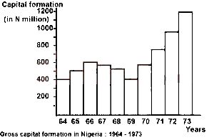
From the diagram above, the gross capital formation from 1964 t0 1966 was
40
The histogram above shows a steady growth of gross capital formation occurred between
41
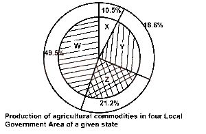
Express the agricultural production of Y in degrees.
43
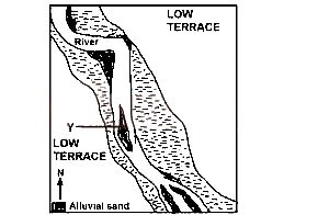
What pattern of flow did the river develop towards the southern edge of the mapped area?
44
In what stage of development is the river?
45
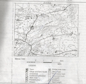
The height of the point marked X is approximately