On September 23 each year, the earth experiences the?
Хариулт
(B)
autumnal equinox
2
Which of the following explains the variation in the lengths of day and night with the seasons?
Хариулт
(B)
Earth's revolution along its orbit
3
Which of the following pairs of longitudes forms a Great Circle?
Хариулт
(B)
40°W and 140°E
4
A layer of very fine wind-deposited sand and silt is known as?
Хариулт
(A)
loess
5
The variation in the volume of water in a river over time is known as its?
Хариулт
(A)
regime
6
Which of the following features is formed by the lower plucking, grinding and dragging action of ice?
Хариулт
(D)
Cirque
7
Which of the following are associated with the lower course of a river?
Хариулт
(C)
Floodplains, ox-bow lakes and deltas
8
The decrease in temperature at the rate of 6.5°C for every 1,000m of ascent is termed?
Хариулт
(B)
normal lapse rate
9
Lands and sea breeze occurs as a result of?
Хариулт
(D)
differential heating of land amd water
10
The main effect of distance from the sea on rainfall is to reduce its?
Хариулт
(A)
amount and seasonality
11
Mediterranean vegetation is described as xerophytic because it?
Хариулт
(B)
is drought resistant
12
Which of the following is regarded as an active factor of soil formation?
Хариулт
(A)
Time
13
The inorganic component of an ecosystem is made up of?
Хариулт
(D)
soil and climate
14
The growth of population at a rate faster than the available resources may result in?
Хариулт
(C)
overpopulation
15
The tundra region is sparsely populated because of?
Хариулт
(B)
harsh environmental conditions
16
Which of the following BEST accounts for rural-urban migration in West Africa?
Хариулт
(C)
limited opportunities in rural areas
17
A linear settlement is most likely to develop on a?
Хариулт
(B)
routeway
18
Which of the following factors is MOST important in bringing about a rapid increase in urban population?
Хариулт
(D)
migration from rural areas
19
The phenomenon whereby the population and functions of a single town in a country far exceed those of others is referred to as?
Хариулт
(B)
dominance
20
A unique system of arable farming in the semi-arid, warm and cool temperate regions is known as?
Хариулт
(B)
dry farming
21
Which of the following BEST explains why the Ganges Delta accounts for the world's largest production of jute?
Хариулт
(C)
Monsoon climate and deep rich soil
22
Which of the following combinations of factors BEST explains the absence of major ocean fishing ground around tropical Africa?
Хариулт
(B)
Narrow comtinental shelf and unindented coastline
23
The port that specializes in receiving and re-exporting goods is known as?
Хариулт
(C)
entrepot
24
The three leading manufacturing countries of the world are?
Хариулт
(C)
U.S.A, Germany and Japan
25
Which of the following shipping routes carries the world's heavies ocean traffic?
Хариулт
(B)
Eastern North America Western Europe
26
In which of these groups of areas is limestone actively quarried for the manufacture cement in Nigeria?
Хариулт
(D)
Ewekoro, Ukpilla and Nkalagu
27
Which of the following BEST accounts for the cultivation of groundnut in the northern part of Nigeria?
Хариулт
(A)
loamy soil
28
A major physical factor restricting the cultivation of perennial crops in the Sudan savannah of Nigeria is the?
Хариулт
(C)
seasonal pattern of rainfall
29
The largest deposit of gold in West Africa is found in?
Хариулт
(A)
Ghana
30
The greatest obstacles to regional economic cooperation in ECOWAS are?
Хариулт
(A)
transportation, different currencies and colonial heritage
31
Which of the following countries can be described as an archipelago?
Хариулт
(D)
Cape Verde
32
In most of West Africa countries, the primary purpose of establishing the railway system was to?
Хариулт
(A)
transport export goods to the coast
33
The geological structure of Africa is largely composed of?
Хариулт
(C)
granitic rocks
34
Which of the following factors account for the traffic on Africa rivers? 1. Availability of cheaper means of transport 2. Seasonal fluctuations of river flow. 3. Pressure of water falls and rapids. 4. Rivers flowing through sparsely populated areas.
Хариулт
(B)
2 and 3
35
The hope for the development of crop and animal husbandry in parts of the Sahara Desert rests on the possibility of?
Хариулт
(A)
tapping the huge reserves of underground water
36
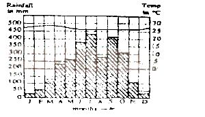
Which type of climate is depicted by the graph?
Хариулт
(D)
Equitorial hot and wet in the northern hemisphere
37
The temperature of this region is characterized by a
Хариулт
(A)
low annual range of about 30oC
38
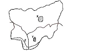
The most important minerals found in the area marked X are
Хариулт
(D)
tin and columbite
39
The major environmental problem associated with the area marked Y is
Хариулт
(D)
gully erosion
40
The most extensive vegetation type in the area marked Z is the
Хариулт
(A)
fresh water swamp
41
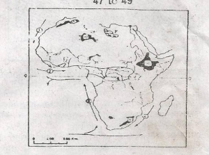
Which of the ocean currents on the map is the Benguela Current?
Хариулт
(C)
3
42
The shaded areas marked Y on the map are
Хариулт
(C)
Oil-producing areas
43
The Ahaggar plateau is the shaded area marked
Хариулт
(B)
Q
44
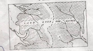
The broken lines in the diagram above represent a
Хариулт
(C)
Watershed
45
The main work of the rivers in the shaded area is likely to be