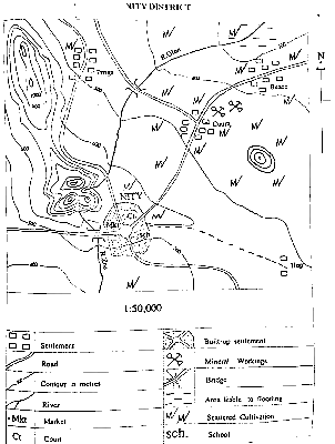
one centimeter on the map represents half kilometer on the ground
3
The approximate length of R. Ofon is
Atbilde
(A)
18.3 km
4
Which of the following settlements is nodal?
Atbilde
(D)
NITY
5
The highest elevation in the mapped area is approximately
Atbilde
(C)
1250 m
6
What is the relief feature marked X?
Atbilde
(C)
Knoll
7
If the map of NITY DISTRICT is reduced to half, what will be the scale of the new map in Representative Fraction (RF)?
Atbilde
(C)
1 : 100,000
8
The relief feature on the west of NITY which extends to the north-western corner of the map is a
Atbilde
(D)
ridge
9
In which settlement is mining practised in the mapped area?
Atbilde
(C)
Coura
10
Where can civil conflicts be resolved in the District?
Atbilde
(D)
NITY
11
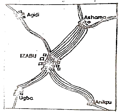
Which of the following statistical methods is represented above?
Atbilde
(C)
Flow chart
12
How many passengers travelled between IZABU and Ashama?
Atbilde
(D)
12,000
13
By how much is the traffic between IZABU and Anikpu more than the traffic between IZABU and Ugba?
Atbilde
(B)
1,500
14
One major advantage of the figure is that, it
Atbilde
(B)
shows quantity and direction together
15
The density of the earth's crust varies from
Atbilde
(D)
2.5 g/cm3 to 3.3 g/cm3
16
Which of the following features is found in the upper course of a river?
Atbilde
(B)
Gorge
17
Which of the following elements of climate is used in the Greek System of climate classification?
Atbilde
(D)
Temperature
18
Two opposite longitudes form
Atbilde
(A)
a Great Circle
19
What is the local time in Town X at 45° E, when it is noon at 0°?
Atbilde
(C)
3.00 pm
20
Which of the following examples of igneous rock is extrusive?
Atbilde
(B)
Basalt
21
Rift valleys are formed through which of the following processes?
Atbilde
(D)
Faulting
22
Caverns, dry valleys and underground drainage are associated with which of the following areas?
Atbilde
(C)
Limestone
23
Which of the following processes of wind action is erosion?
Atbilde
(B)
Deflation
24
From what are carbonaceous types of sedimentary rocks made of?
Atbilde
(C)
Vegetable matter
25
Which of the following is a drainage pattern?
Atbilde
(D)
Trellis
26
The predominant process of weathering in the desert region is
Atbilde
(C)
physical
27
The instrument, barometer, is used for measuring
Atbilde
(D)
air pressure
28
Which climatic type has winter rain
Atbilde
(B)
Meditaerranean
29
Which of the following igneous intrusions is horizontally inclined?
Atbilde
(A)
Sill
30
Which of the following rocks is not metamorphic
Atbilde
(A)
Shale
31
If the temperature reading at an observatory located on top of a dormant volcano is 6°C what will be the temperature at the bottom of the volcano if the observatory is 3,000 meters from the surrounding lowland?
Atbilde
(C)
25.5°C
32
A crescentic depositional feature found in desert mice is
Atbilde
(D)
Barchan dune
33
Which of the following is not a volcanic feature?
Atbilde
(D)
Ventifact
34
Earth's surface is warmed by solar energy through
Atbilde
(C)
conduction
35
Vosges and black forest mountains are examples of
Atbilde
(B)
block
36
How many standard time zones will a country with a longitudinal extent of 150° have?
Atbilde
(A)
10
37
One important consequence of the location of Nigeria between latitudes 41 and 14" North of the equator is that
Atbilde
(D)
Some parts Of the country enjoy a hot, wet tropical climate throughout the year
38
Subsistence farming is practiced when people
Atbilde
(A)
grow crops for consumption
39
Which of the following factors hinder the development of tourism? I. Spread of diseases II. Escalation of crime Ill. Adequate publicity IV. Inadequate appreciation of leisure
Atbilde
(C)
I and IV only
40
The busiest ocean trade route is the
Atbilde
(C)
North Atlantic route
41
A settlement type in which buildings are aligned along a road or river is said to be
Atbilde
(C)
linear
42
The major causes of change in population size are
Atbilde
(A)
births, marriage and deaths
43
Banking, insurance, and teaching are examples of which industry?
Atbilde
(B)
Tertiary
44
A rapid population growth can result from
Atbilde
(D)
improved medical care
45
The term relative location of a settlement refers to
Atbilde
(B)
the position of a settlement in relation to others