The most obvious physical feature that distinguishes undisturbed mature soil from an immature soil is the
תְשׁוּבָה
(B)
layered profile
4
The direction of flow of ocean currents is determined mainly by the
תְשׁוּבָה
(C)
prevailing winds and the rotation of the earth
5
The medium class of layered cloud which brings continuous rain, snow or sleet is the
תְשׁוּבָה
(D)
nimbostratus
6
The biodiversity of an ecosystem may be reduced through the
תְשׁוּבָה
(A)
extinction of plant species
7
A soft, black opaque carbonaceous rock that can be used to make pencils is
תְשׁוּבָה
(B)
graphite
8
The vegetation that is characterized by tall trees climbing plants and creepers in the Amazon is called
תְשׁוּבָה
(C)
selvas
9
One predominantly temperate grain that is being cultivated in some tropical areas today is
תְשׁוּבָה
(D)
wheat
10
The scientist who prepounded the theory of continental drift was
תְשׁוּבָה
(A)
Alfred Wegener
11
A sedimentary rock formed only in seas and oceans in warm tropical and subtropical environments is
תְשׁוּבָה
(A)
shale
12
Exfoliation and rock disintegration are weathering processes only found in the
תְשׁוּבָה
(C)
desert region
13
An area of the world that is likely to have 24-hour sunshine on July 15 of any year is the
תְשׁוּבָה
(D)
Northern polar area
14
Where winds are onshore, warm ocean currents will bring a type of condition to the coastland that is
תְשׁוּבָה
(B)
warm and wet
15
The speed of the wind is usually measured by
תְשׁוּבָה
(A)
an anemometer
16
Acid lava is rich in
תְשׁוּבָה
(C)
silica
17
The live commentary of a football match which started at 4:00pm at a place on longitude 15°E will be received by a listener in a town on longitude 160°W at
תְשׁוּבָה
(B)
4:20am same day
18
During winter, the Eskimos live in
תְשׁוּבָה
(D)
igloos
19
Johannesburg, Jos and Galhivare are similar in that they all
תְשׁוּבָה
(C)
grew because of the presence of minerals
20
The shaduf method of irrigation was first practiced in
תְשׁוּבָה
(A)
Egypt
21
Dairy farming is most notable in
תְשׁוּבָה
(B)
Denmark
22
The least of the factors to be considered in the location of industries is
תְשׁוּבָה
(D)
climate
23
The rise in the population of an area can be measured easily by
תְשׁוּבָה
(C)
adding the natural increase to the migration
24
Transportation is an important economic activity because it
תְשׁוּבָה
(A)
promotes diffusion of innovation and ideas
25
Which of these sets enhances nucleation of rural settlements?
תְשׁוּבָה
(C)
Fertile broad plains and natural harbours
26
The movement of a group of people from a village to an irrigation project area may be described as
תְשׁוּבָה
(D)
rural-rural migration
27
The most important factors influencing the distribution of population in the world are
תְשׁוּבָה
(A)
climate, relief, soils and mineral resources
28
The most dreaded pest in the Cotton Belt of the U.S.A is the
תְשׁוּבָה
(C)
bollweevil
29
The Benguela current is to Namibia what the canaries current is to
תְשׁוּבָה
(D)
Mauritania
30
The two prominent highlands at the Nigeria-Cameroun border are
תְשׁוּבָה
(B)
Mandara and Alantika
31
An important mineral deposit in South Africa which has attracted a large number of white settlers is
תְשׁוּבָה
(C)
gold in Witwatersrand
32
The prosperity of Kenya depends upon the cultivation of
תְשׁוּבָה
(D)
coffee, maize and sisal
33
One major feature of manufacturing in West Africa is that the industries
תְשׁוּבָה
(B)
produce mainly for domestic market
34
The most important air masses which affect the climate of Nigeria are the
תְשׁוּבָה
(C)
tropical maritime and the tropical continental
35
The low rainfall along Cape Three Points in Ghana is due to the
תְשׁוּבָה
(C)
prevalence of south west winds
36
In Nigeria, the dominant trees of the Guinea Savannah include
תְשׁוּבָה
(B)
isoberlinia, shea butter and silk cotton
37
From its source to its mouth, the River Niger passes through
תְשׁוּבָה
(C)
Guinea, Mali, Niger and Nigeria
38
An environmental hazard which occurs slowly and unnoticed in the oil-producing region of the Niger Delta of Nigeria is
תְשׁוּבָה
(B)
pollution
39
One basic mineral that is common to Sokoto, Ewekoro, Calabar and Nkalagu is
תְשׁוּבָה
(C)
limestone
40
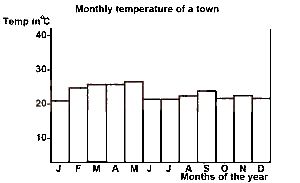
The modal temperature for the town is
תְשׁוּבָה
(A)
23oC
41
The annual range of temperature for the town is
תְשׁוּבָה
(A)
7oC
42
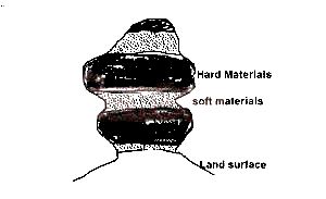
The feature is a product of
תְשׁוּבָה
(B)
wind abrasion
43
The landform is a
תְשׁוּבָה
(D)
rock pedestal
44
The technique that would produce the most accurate contoured map of a small area is
תְשׁוּבָה
(A)
Prismatic compass survey
45
In Nigeria, continentality poses the greatest hindrance to economic development in the