The main advantage of the chain survey over the prismatic compass survey is that the former
תְשׁוּבָה
(D)
closes its boundaries with no correction
2
The main use of the Abney Level in surveying is to determine the
תְשׁוּבָה
(A)
angle of inclination
3
A typical example of landforms produced by marine erosion is a
תְשׁוּבָה
(D)
stack
4
When the gradient of a river channel changes from a steep to a gentle angle, the main activity of the river will be
תְשׁוּבָה
(A)
depositing
5
The period when the earth is furthest from the sun is
תְשׁוּבָה
(A)
aphelion
6
A traveller crossing the international Date Line from America to Asia at 12 midnight on Sunday, would have to change his watch to 12 midnight on
תְשׁוּבָה
(B)
Monday
7
Lakes formed as a result of landslides, screes or avalanches are known as
תְשׁוּבָה
(B)
barrier lakes
8
In many areas, limestone rocks are resistant to water erosion on their surfaces and form uplands because of their
תְשׁוּבָה
(D)
joints and pervious nature
9
Fluid, basic lava flow is likely to give rise to a volcanic
תְשׁוּבָה
(C)
shield
10
Urban floods are mainly caused by
תְשׁוּבָה
(C)
blockage of drains and waterways
11
The vegetation of the warm Temperate Eastern Margin is characterized by
תְשׁוּבָה
(B)
mixed deciduous and coniferous forests
12
The heavy dark soil associated with floodable valley-bottoms is a
תְשׁוּבָה
(D)
hydromorphic soil
13
Which of the following is a major environmental problem in heavily industrialized regions?
תְשׁוּבָה
(D)
Acid rain
14
A fog is most likely to develop when a
תְשׁוּבָה
(B)
warm moist wind blows over a cold current
15
One factor which helps to account for the dryness of the Sahara desert is the
תְשׁוּבָה
(B)
persistence of a high pressure belt over the area
16
The circulation of the oceans and the atmosphere primarily help to redistribute and equalize global
תְשׁוּבָה
(A)
heat
17
Soils with well developed profiles formed mainly under the influence of the regional climate and vegetation are said to be
תְשׁוּבָה
(B)
zonal
18
Environmentalists agree that there is a general rise in sea level as a result of
תְשׁוּבָה
(C)
global warming
19
The set of trees most suitable for pulp and paper making is
תְשׁוּבָה
(C)
spruce, fir and pine
20
The population of a certain country was observed to be 46 million males and 41 million females within a land area of about 173,000km2. What is the average density of the population?
תְשׁוּבָה
(A)
503 persons per km2
21
Modern satellite towns are commonly characterized by
תְשׁוּבָה
(B)
suburban location, planned layout and spacious surroundings
22
An extensive fertile plain with a relatively low population will most likely be characterized by
תְשׁוּבָה
(D)
scattered rural settlements
23
International agreements in the fishing industry are necessary in order to protect whale and seal from
תְשׁוּבָה
(B)
stock extinction
24
Many industries in Europe and America have established branches in South East Asia in order to reduce
תְשׁוּבָה
(A)
production costs
25
Expressways mainly help intracity traffic in that
תְשׁוּבָה
(A)
the multiple lanes can hold more traffic
26
The best climate for the production of tea is
תְשׁוּבָה
(B)
maritime
27
The harmattan wind in Nigeria is associated with
תְשׁוּבָה
(A)
Tropical Continental Airmass
28
Three ethnic groups of the Niger Delta region of Nigeria are
תְשׁוּבָה
(C)
Ijo, Urhobo and Itshekiri
29
The sequence of savannah vegetation zones in Nigeria towards the northern part is
תְשׁוּבָה
(B)
Derived, Guinea, Sudan and Sahel
30
Oil refineries are found in which of the following sets of states?
תְשׁוּבָה
(D)
Rivers, Delta and Kaduna
31
In Nigeria, hydroelectric and thermal energies are generated respectively in
תְשׁוּבָה
(C)
Kainji and Oji river
32
On the Jos plateau, tin and columbite are obtained mainly from
תְשׁוּבָה
(D)
alluvial deposits
33
Which of the following groups of people is not found in West Africa?
תְשׁוּבָה
(D)
Shona
34
The most important gold mining town in Africa is
תְשׁוּבָה
(C)
Johannesburg
35
An African port that handles more of other countries products than its own is
תְשׁוּבָה
(B)
Cape Town
36
Power for aluminium smelting is one of the principal objectives of the hydro-electric project in
תְשׁוּבָה
(A)
Kariba
37
An example of a horst in Africa is
תְשׁוּבָה
(B)
Ruwenzori
38
The group of countries that produce most of the cocoa in West Africa is
תְשׁוּבָה
(C)
Ghana, Nigeria and Cote d'Ivoire
39
The two dams found in the Upper and Lower Nile respectively are
תְשׁוּבָה
(C)
Aswan and Jebel Aulia
40
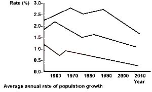
Which of these statements is true concerning the three rates illustrated above?
תְשׁוּבָה
(B)
The world rate is closer to that of the more developed region than that of the less developed
41
The range of population growth in the less developed regions during the period illustrated is approximately
תְשׁוּבָה
(B)
1.6 to 2.7%
42
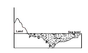
the ocean feature at point S is best described as
תְשׁוּבָה
(C)
an ocean dip
43
The section labelled R represents
תְשׁוּבָה
(C)
a continental slope
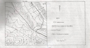
44
A profile drawn along LK, north east of River Aye describes