The human activity that can improve composition of the atmosphere is
پاسخ دهید
(A)
Use of chemicals
3
Which of the following is a sedimentary rock.
پاسخ دهید
(B)
shale
4
These are landforms producing agent except
پاسخ دهید
(C)
storms
5
The function performed by urban to the rural settlement in supply of
پاسخ دهید
(D)
maufactured goods
6
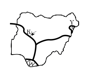
Use the map below to answer this question above
The feature marked Y on the map is?
پاسخ دهید
(D)
mandara mountain
7
Use the map below to answer this question above
What is the feature labelled K on the map is
پاسخ دهید
(C)
lake kainji
8
The benefits of international trade to developing nations include the following except
پاسخ دهید
(C)
Strains international trade relation
9
Which of the following is not caused by the earth's rotation?
پاسخ دهید
(B)
Seasonal changes
10
The following are responsible for the concentration of industries in eastern United States of America except
پاسخ دهید
(C)
Inadequate capital
11
Which of the following farming activity best describes the rearing of only animals like cattle, sheep and goat mainly in the savanna belt of the north?
پاسخ دهید
(C)
pastoral farming
12
The outer structure of the earth is made up of the following except?
پاسخ دهید
(A)
mesosphere
13
Which of the following is an importance of the atmosphere to living organisms?
پاسخ دهید
(B)
It provides oxygen for animals and plants for respiration
14
The correct arrangement of the layers of the earth crust from the surface to the interior is
پاسخ دهید
(D)
sial, sima, mantle and core
15
If the scale of a map is 2cm to 1km, what is the ground distance if the distance between two towns on the map is 20cm
پاسخ دهید
(C)
10km
16
If the scale of two maps are (a;1:100,000 and b;1:400,000) what is the ground distance if the distance between two towns on the maps is 10cm
پاسخ دهید
(A)
10km, 40km
17
Which of the following is a reason for the high volume of trade between Nigeria and developed countries?
پاسخ دهید
(C)
colonial Ties
18
The following are seaports used in the North Atlantic sea route except
پاسخ دهید
(B)
Lagos-Montreal
19
_______ is the condition of the lower atmosphere of a place over a short period
پاسخ دهید
(B)
weather
20
In a combined maximum and minimum thermometer, the difference between the hottest and coldest daily temperature for that day gives the
پاسخ دهید
(A)
Diurnal range of temperature
21
_______ is defined as the total surrounding or medium of any organism in a given area
پاسخ دهید
(C)
Environment
22
Which of the following processes leads to the loss of carbon from the air
پاسخ دهید
(D)
photosynthesis
23
On maps, lines drawn to join all places in the ocean having equal degree of salinity are called
پاسخ دهید
(A)
isohalines
24
Where the salinity of an ocean is high;
پاسخ دهید
(B)
the ocean water is dense and creeps at the bottom of the ocean towards low salinity areas
25
The type of water left in the soil after excess water has been drained off, following heavy rainfall is known as
پاسخ دهید
(A)
Field capacity
26
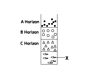
The part labelled X in the soil profile above is known as
پاسخ دهید
(D)
bedrock
27
Which of the following is not a graphical representation of statistical data?
پاسخ دهید
(C)
Shaded map
28
Which of the following is a vegetation characteristics of the Tropical rainforest?
پاسخ دهید
(B)
Tough, small, leathery, hairy leaves to guard against excessive transpiration
29
Which of the following is a problem of landlocked countries
پاسخ دهید
(D)
political indepedence
30
One of the following is not a problem involved in harnessing solar energy?
پاسخ دهید
(B)
Adequacy of capital
31
One of the following surveying instruments is used to set out lines at right angles to the main chain line
پاسخ دهید
(A)
Optical square
32
________is the failure of the end point of a closed traverse to fall exactly on the point of origin of the transverse
پاسخ دهید
(C)
Error of closure
33
What is the process of lowering and levelling of the earth surface by gradual breaking and wearing away of such earth's surfaces.
پاسخ دهید
(B)
Denudation
34
Which of the following is an effect of the earth's revolution?
پاسخ دهید
(B)
It determines a year
35
The soil gains nitrogen through one of the following except
پاسخ دهید
(A)
Denitrification
36
Which of the following is a way of controlling soil erosion
پاسخ دهید
(B)
Contour ploughing
37
__________ is a highland area which seperates the headstreams of rivers flowing in different directions but rising from the same mountainous source
پاسخ دهید
(C)
watershed
38
___________ is a layer of very fine wind-deposited sand and silt?
پاسخ دهید
(A)
loess
39
An important mineral deposit in south Africa which has attracted a large number of white settler is
پاسخ دهید
(D)
Aluminium in Johannessburg
40
Which of the following gives the correct full meaning of G.I.S?
پاسخ دهید
(D)
Geographic Information System
41
Sparse population in the middle belt of Nigeria can not be attributed to
پاسخ دهید
(B)
Absence of major minerals
42
In Nigeria, which of the following vegetation zones is best known for timber exploitation?
پاسخ دهید
(D)
Rain forest
43
The following are the importance of highland in Nigeria except
پاسخ دهید
(B)
settlement sites
44
Which of the following tourist centres is wrongly paired?
پاسخ دهید
(A)
Eiffel Tower - Germany
45
The state in Nigeria with the highest population density is
پاسخ دهید
(A)
Anambra
46
Geo-referencing in GIS is referred to as
پاسخ دهید
(A)
Assigning spatials location to a data
47
A device for transferring information from analogue map into computer for further manipulation is
پاسخ دهید
(B)
Digitizer
48
The system of agriculture referred to as "Land rotation" is
پاسخ دهید
(D)
Shifting cultivation
49
These are areas of crude oil production in Nigeria except
پاسخ دهید
(A)
Afam
50
Which of the following is not a factor that favours industrial concentration in Western Nigeria?
پاسخ دهید
(C)
Creativity of people in the area
51
Which of the following rocks is organically formed?
پاسخ دهید
(B)
Coal
52
River regime is best described as the
پاسخ دهید
(B)
seasonal variation in the volume of water in a river
53
One of the features of wind deposition is
پاسخ دهید
(C)
an inselberg
54
Jos plateau is an example of a
پاسخ دهید
(B)
Dissected plateau
55
A line joining all points of equal salinity is an
پاسخ دهید
(C)
Isohaline
56
Tropical savanna vegetation is characterized by
پاسخ دهید
(A)
drought - resistant trees
57
An example of a coastline of emergence is
پاسخ دهید
(A)
a raised beach
58
Which of the following is associated with savanna vegetation
پاسخ دهید
(C)
Scrub
59
Which of the following statements is true of the North Atlantic Sea route?
پاسخ دهید
(A)
It is the busiest sea route
60
A settlement located where two rivers meet is called a
پاسخ دهید
(B)
confluence town
61
Exports from Mali are most likely to pass through the Sea port at
پاسخ دهید
(D)
Abidjan
62
The coastal regions of Sierra leonne record an annual rainfall of over
پاسخ دهید
(B)
4,000 mm
63
Kossou Dam is located on River
پاسخ دهید
(B)
Bandama
64
Nigeria's major export commodity is
پاسخ دهید
(D)
Petroleum
65
A major percentage of the world's exports of citrus fruits is from the
پاسخ دهید
(D)
Mediterranean region
66
Which of the following has the highest salinity
پاسخ دهید
(C)
red sea
67
The dam which is not used in the gezira is the
پاسخ دهید
(D)
Jebel Azula
68
Which statement is not true of the middle belt in Nigeria?
پاسخ دهید
(D)
None of the above
69
Which of the following zones is the least industrialized in Nigeria?
پاسخ دهید
(A)
Lokoja - Ajaokuta
70
Which of the following towns is not a precolonial town
پاسخ دهید
(C)
Enugu
71
Which of the following lakes owes its origin mainly to faulting?
پاسخ دهید
(C)
Lake Malawi
72
In the desert region the most prominent agent of erosion is
پاسخ دهید
(D)
Wind
73
One of the disadvantages of water transport is that it
پاسخ دهید
(C)
is not flexible
74
Which of the following is not a sea route?
پاسخ دهید
(A)
London - moscow - Baghdad
75
The tourist centre of Ogbunike care is located near