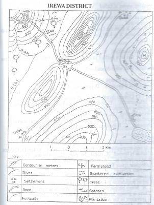
The scale of the map above in representative fraction (RF) is
Απάντηση
(B)
1 : 50,000
2
The crowfly distance from Doba to Sasi is approximately
Απάντηση
(C)
5.5km
3
What is the direction of IREWA and Oki?
Απάντηση
(D)
South-East
4
The symbol A950 to the north-east of IREWA is
Απάντηση
(D)
trigonometrical station
5
The feature marked H on the map can best be described as a
Απάντηση
(B)
conical hill
6
Which of the following settlements is located at the highest altitude?
Απάντηση
(D)
Oki
7
The most likely occupation of the people of Oki is
Απάντηση
(C)
farming
8
Which of the following best explains the growth of IREWA?
Απάντηση
(A)
Nodal town
9
The most probable reason for the construction of the road from IREWA through Sasi to the plantation is
Απάντηση
(D)
to evacuate farm products from the plantation to the market at IREWA
10
Which of the following towns may not be visible from the feature marked H?
Απάντηση
(D)
Oki
11
Which of the following methods of representing statistical data would be most suitable for showing annual production of rice on a month-to-month basis?
Απάντηση
(C)
Bar graph
12
Which of the following types of bar graphs shows increases and decreases compared with a given average?
Απάντηση
(A)
Divided bar graph
13
Simple bar graphs can most suitably be used to represent all the following except
Απάντηση
(A)
Value of a country's leading exports and imports
14
The temperature of the environment changes with
Απάντηση
(B)
altitude
15
The degree of longitude through which the Earth spins within 3hours is
Απάντηση
(C)
45°
16
An example of physical weathering process is
Απάντηση
(B)
exfoliation
17
Which of the following rocks is sedimentary?
Απάντηση
(A)
Coal
18
Granitic rocks contain
Απάντηση
(B)
silica and iron
19
Chemical weathering can take place most effectively when the conditions are
Απάντηση
(C)
cold and wet
20
The temperature at the foot of a mountain is 20°C. If the mountain is 6,000 metres above sea level, what will be the approximate temperature at the top of the mountain?
Απάντηση
(A)
- 19.0°C
21
The planet which revolves round the sun in a clockwise direction is
Απάντηση
(D)
uranus
22
Under the Greek system of climatic classification, the world is divided into
Απάντηση
(D)
torrid, temperate and frigid zones
23
"It is a pinnacle of calcium that grows from the floor of limestone cave." This is a description of
Απάντηση
(B)
stalagmite
24
What is the shape of the Earth?
Απάντηση
(A)
Geoid
25
Which of the following processes is associated with the ejection of magma and other related materials from deep below the Earth onto the Earth's surface?
Απάντηση
(D)
Vulcanicity
26
The steep-sided flat-floored valley in hot deserts through which occasional flash floods flow is known as
Απάντηση
(C)
playa
27
Which of the following features is of volcanic origin?
Απάντηση
(A)
Sill
28
Rocks in the inner core of the Earth are rich in
Απάντηση
(B)
nickel and magnesium
29
Which of the following conditions occur during equinox?
Απάντηση
(B)
All places across the globe experience equal lengths of day and nights
30
The sea water thrown up the beaches by the breaking waves is called
Απάντηση
(A)
backwash
31
Which type of rainfall occurs when two air masses of different temperature and other physical properties meet?
Απάντηση
(C)
Cyclonic
32
Two towns X and Y are situated on the Equator. If town X is on the Greenwich Meridienand town Y is on longitude 45°E, what will be the town Y, if the time at town X is 4.00pm?
Απάντηση
(D)
7.00pm
33
Mountain of denudation is another term for
Απάντηση
(D)
residual mountain
34
When the moon comes in between the Earth and the sun in a perfect line, which of the following eclipse occurs?
Απάντηση
(C)
Solar
35
Which of the following desert landforms is associated with wind deposition?
Απάντηση
(D)
Barchan
36
Factors which influence the practice of irrigation include all except
Απάντηση
(B)
high rainfall
37
Which of the following is a service industry?
Απάντηση
(A)
Banking industry
38
A negative effect of mineral exploitation is
Απάντηση
(C)
pollution
39
The system of agriculture which combines the growing of crops and rearing of animals is known as
Απάντηση
(C)
mixed farming
40
Which of the following statements is true of transhumance?
Απάντηση
(A)
It is the seasonal migration of animal rearers in mountainous areas
41
Most rural settlements in developing countries of Africa
Απάντηση
(B)
are dispersed
42
Which of the following environmental resources is non-renewable?
Απάντηση
(B)
Mineral
43
A town which is situated at the meeting point of roads is termed
Απάντηση
(A)
nodal
44
A major problem of air transportation in developing countries is
Απάντηση
(C)
inadequate capital
45
All these factors determine what a country can produce except