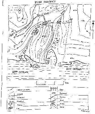
What is the approximate distance from Obasa to Oju as the crowflies?
إجابة
(A)
10km
5
The bearing of Danki from Oju is
إجابة
(C)
285°
6
The feature in the south-west of Musa is
إجابة
(A)
a cliff
7
The lower section of R. Kam is showing signs of old stage because of the presence of
إجابة
(D)
meander
8
Musa settlement is likely to be
إجابة
(B)
a fishing village
9
A seaport can be sited in all the following settlements except
إجابة
(D)
Bama
10
All the following settlements are intervisible from KUSH except
إجابة
(C)
Musa
11
The annual range of temperature is
إجابة
(B)
2 °C
12
Which climatic region is represented by the data?
إجابة
(D)
Tropical Monsoon
13
Which of the following towns experiences the type of climate represented?
إجابة
(C)
Ward (Nigeria)
14
The mean temperature from July to December is
إجابة
(C)
27.5 °C
15
The type C of Koppen's climate is the
إجابة
(A)
warm temperate
16
A fall in sea level can lead to the formation of
إجابة
(B)
raised beach
17
Which of the following is a process of river transportation?
إجابة
(D)
Suspension
18
Which of the following are process of physical weathering? I. Frost action II. Hydrolysis III. Oxidation IV. Temperature Changes
إجابة
(B)
I and IV only
19
Town A is located on longitude 15°E, while town B is located on longitude 45°E. If the local time in town A is 6.00am, what will be the local time in town B?
إجابة
(D)
8.00am
20
The predominant process of weathering in desert regions is
إجابة
(D)
physical
21
Which of the following factors affect temperature? I. Latitude II. Time III, Wind direction IV. Ocean current
إجابة
(D)
I and IV only
22
Which climate is characterized by winner rain and summer drought?
إجابة
(B)
Mediterranean
23
Temperature decreases with height in the
إجابة
(B)
troposphere
24
A temporary salt lake found in arid and semi-arid area is also called
إجابة
(D)
messa
25
Hamada is another name for
إجابة
(C)
rocky desert
26
Petroleum is usually found in
إجابة
(D)
sedimentary rocks
27
One of the following features is an example of faulting
إجابة
(C)
Rift valley
28
How many Standard Time Zones will a country with a longitudinal extent of 155° have?
إجابة
(B)
11
29
The day in which the length of day and night are equal everywhere on Earth is
إجابة
(C)
21st March
30
A rock in which water cannot easily pass through is termed
إجابة
(C)
impermeable
31
A great circle route is used to
إجابة
(B)
save time and fuel
32
The difference between the hottest and coldest months of a place is the
إجابة
(C)
annual range temperature
33
Which of the following is not a proof of the spherical shape of the Earth?
إجابة
(D)
Coastal submergence
34
A plateau highly eroded by rivers and broken by deep narrow valleys is
إجابة
(C)
dissected plateau
35
Calculate the distance between town Y which is on latitude 40° N and town Z which is on latitude 10°S
إجابة
(D)
5550km
36
Which of the following problems hinder international trade? I. Political instability II. Low tariffs III. Inadequate foreign exchange IV. Strained relations
إجابة
(D)
I, III and IV only
37
The hinterland of a port is
إجابة
(D)
area served by a port
38
Which of the following are the benefits of transportation to a country? I. Diffusion of ideas II. Acculturation III. Unemployment IV. Enhanced trade
إجابة
(D)
I, III and IV only
39
Which of the following are characteristics of manufacturing induitries in Tropical Africa? I. Export-oriented II. Labour intensive III. Consumer-oriented IV. Diversified production
إجابة
(B)
II and III only
40
Which factor for location of industries explains the establishment of cement industries near areas of limestone deposits?
إجابة
(C)
Source of raw material
41
The major problem facing the railway transportation compared to road transportation is
إجابة
(D)
lack of flexibility
42
Which of the following is not-a sea route?
إجابة
(A)
London -> Moscow -> Baghdad
43
One characteristic feature of intensive farming is that, it is practised in urban centres where
إجابة
(B)
human population is high
44
Which of the following features promote the development of nucleated settlement?
إجابة
(D)
Fertile soils and steep valleys
45
In an economy where the major problem to industrial development is the fear of failure, the most important policy to revitalize the industrial sector of such an economy is