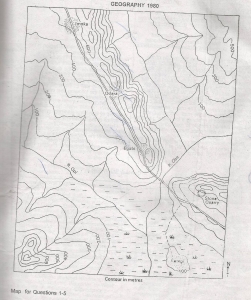
The true bearing, to the nearest degree of the highest peak in the mapped area from the center of the bridge across River Obe is?
إجابة
(D)
319°
2
Ketegi settlement is typically a
إجابة
(E)
confluence settlement
3
The feature running across the middle of the mapped area from N.W TO S.E, on which most of the settlements are located, is a (an)
إجابة
(E)
cuesta
4
Which of these is not a likely reason why the only road on the mapped area runs along the elevated feature ?
إجابة
(E)
There is no other place through which the road could pass except on the elevation
5
A ship's radioed message on the high sea at 5.45pm was heard at Abidjan(5°W) at 11.15a.m on the same day.Find the position of the ship
إجابة
(B)
92° 30'E
6
What feature would you associate with a rejuvenated river?
إجابة
(A)
a waterfall
7
The intensity of the sun's heat is not much in polar regions because
إجابة
(D)
the angle of insolation is low
8
Which of the following is a correct pair?
إجابة
(E)
River/Cut-off
9
Which of the following rocks is composed of the skeletons of microscopic sea plants and animals?
إجابة
(C)
Chalk
10
Annual rainfall is low and erratic.The vegetation is scanty,although temperature is generally high, yet the daily range of temperature is very high.
Which of the following is the climatic type described above?
إجابة
(E)
Hot desert
11
Rain falls mainly during the warm summer months.Summer temperature rarely exceeds 18.3°C.Annual rainfall is often below 125cm.Which of these crops is most unlikely to do well in the area described above?
إجابة
(A)
Wheat
12
Which of these industries is usually located at the source of its major raw materials?
إجابة
(A)
cement manufacturing
13
Which one of the following states of Nigeria is a major kola-nut producer?
إجابة
(D)
Bauchi
14
Nigeria's new federal capital territory shares boundaries with four states.What are these states?
إجابة
(C)
Plateau,Kwara,Niger and Kaduna
15
Which are three main export crops of Uganda?
1.Bananas 2.Coffee 3.Cotton 4.Groundnuts 5.Sugar 6.Cassava 7.Tobacco
إجابة
(B)
2&3&7
16
Which of the following is the least important reason for promoting manufacturing industries by West African Nations?
إجابة
(E)
to produce locally everything needed
17
Which of the geographical reasons below least supports the existence of ECOWAS?
إجابة
(E)
the countries in the community share similar physical characteristics
18
Dodoma is to Tanzania as .........is to Nigeria
إجابة
(B)
Abuja
19
What is the cause of the double rainfall maximal in southern Nigeria?
إجابة
(E)
overhead sun on the equator
20
Textile industries in Nigeria are characterized by the following features except one?
إجابة
(A)
full automation
21
The following is a description of a type of climate:'very cold winters(-34°C or colder), hot summers (21°C); mean annual rainfall under 380mm,most of it occurring in summer'. To which of the following does the description relate?
إجابة
(E)
temperate eastern margin
22
which of the following features is NOT characteristics of a glaciated area?
إجابة
(C)
Interlocking spurs
23
Which one of the following terms give us the best general description of the relief of West Africa?
إجابة
(D)
plain and plateaux
24
which of the following is the most important reasons why the highest densities of cattle in West Africa are to be found in the Sudan and Sahel Savannah zones?
إجابة
(D)
the two zones are largely free from tsetse flies
25
which of the following countries have few resources and yet has develop industries tremendously?
إجابة
(A)
United kingdom
26
Which among the following is a producer of coal?
إجابة
(A)
Wankie (Zimbabwe)
27
Which of these is the least important advantage of the transcontinental railways in Europe and North-America?
إجابة
(E)
Employment of labour
28
Which of the following can be regarded as the backbone of a modern industrial economy?
إجابة
(E)
Iron and Steel industry
29
A hinterland is?
إجابة
(B)
an area which is far from the coast
30
very large in area but very low in population;which of the following countries fits this description best?
إجابة
(D)
Zaire
31
The industrial economy of South-Africa is NOT based on one of the following factors:
إجابة
(B)
abundant crude petroleum resources
32
Volcanoes are considered a natural resource because of all but one of the following reason
إجابة
(D)
volocanic explosion helps control world population
33
which of these sets best arranges these settlement types in ascending order in terms of their complexity of function?
إجابة
(A)
hamlet,village,town,city,metropolis
34
the great agricultural regions of the world includes all but one of these
إجابة
(E)
the Sahel of West Africa
35
which of these sea routes carries the heaviest traffic?
إجابة
(A)
the North Atlantic routes between europe and North America
36
the Nigerian petroleum refineries are located at one of the following pairs of town?
إجابة
(E)
Port-Harcourt and Warri
37
Nigeria's proposed Iron and steel industry based on the direct reduction would be located at;
إجابة
(D)
Warri
38
Vegetables are usually grown near markets or their places of consumption because?
إجابة
(A)
they are easily perishable
39
Industries can be classified as either light or heavy.
Which of the following groups of industries can be classified as light?
إجابة
(A)
Textile, clothing, footwear and printing
40
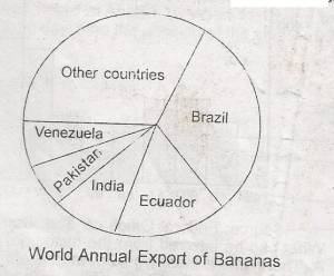
From the above diagram, Brazil's contribution to the export of bananas is
إجابة
(C)
30%
41
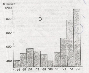
Gross capital formation in Nigeria 1964-1973, what can be inferred from the histogram above?
إجابة
(B)
capital formation in the last two years exactly equalled those of all previous years combined
42
Which of the following is the appropriate shape of the section from A to B? choose the correct answer from the options above
إجابة
(D)
D
43
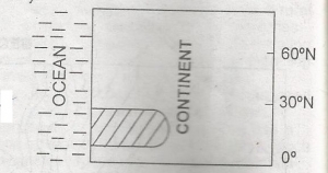
Identify the shaded natural region in the diagram
إجابة
(C)
Hot desert
44
The ground distance along the river from the confluence of Rivers Obe and Opi to the bridge across River Obe is 5.5kilometres. What is the scale of the map in Representative Fraction?
إجابة
(E)
1:1,000,000
45
Which one of the following states of Nigeria is a major cotton producer?